Maurice Channel
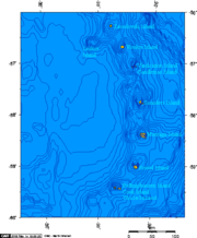
Maurice Channel is a strait 1.5 nautical miles (3 km) wide between Bellingshausen Island and Cook Island, in the South Sandwich Islands off Antarctica. In 1820, Fabian Gottlieb von Bellingshausen indirectly indicated the existence of the strait by describing Southern Thule as consisting of one high rock and three small islands. The strait was charted in 1930 by Discovery Investigations personnel on the Discovery II and named for Henry Gascoyne Maurice, a member of the Discovery Committee.
Read article
Top Questions
AI generatedMore questions
Nearby Places
Bellingshausen Island
Island in the Southern Thule group of the South Sandwich Islands

Cook Island, South Sandwich Islands
Island in the Southern Thule group of the South Sandwich Islands
Basilisk Peak
Mountain in the South Sandwich Islands
Hardy Point
Mount Harmer
Mountain on Cook Island in the subantarctic
Salamander Point
Mount Holdgate
Volcano on Cook Island in the subantarctic

Southern Thule
Island group in the South Sandwich Islands